The Town of Peace River, originally called Peace River Crossing, was one of the first places in the area settled by the pioneers. Before that, it had long been a meeting place for the Indigenous peoples of the region. As the meeting place of three different waterways—the Peace River, Heart River, and Smokey River—it was a natural place to settle.
A tour of our local lookouts lets you bask in the amazing views the valley offers as well as gives you a taste of the early history of the region. If you’re the adventurous type, several of the locations let you walk or even hike a short distance to get a little exercise in (though this is always optional). So grab a specialty coffee from J’s Java Domain, bring your water bottle and walking shoes (if you plan on walking), and let’s hit the road for a tour of the local sites.
Local Explorer’s Tip: While the valley is beautiful at any time of day, morning or afternoon are optimal times for seeing the valley defined and highlighted by the angle of the sun (as opposed to the noon hour). To enjoy this tour with a lunch stop as described, plan to start between 10-11 a.m. Or, if you’re starting later, have your lunch first (beginning with the last two stops, the 12 Foot Davis Events Park and Sagitawa Lookout, which is an idyllic spot for munching on food out in the fresh air) and then go back to the beginning of the itinerary to complete your tour.
Dr. W. Greene’s Cairn
Dr. William Greene was an aviation pioneer (as in, one of the first eight people to have a successful flight ever), doctor, engineer, and dentist who moved to Peace River in 1911. He loved Peace River and the surrounding area and poured his heart and soul into the community. The local Masonic lodge, of which he was an active member, erected a cairn in his memory near the junction of the Grouard Trail (used by many pioneers) and the road that used to lead to Twelve Foot Davis’s gravesite, but which has now been washed out. If you look southwest from the cairn, you’ll see the nature preserve set aside in his honour stretching south in a swath of virgin green forest (just west of Highway 2).
How to get there:
Driving (about 2 minutes) and walking (about 2 minutes):
From Main Street (100th Street) Peace River, head east on 100th Avenue up the hill to a small roadside pullout on the north side of the road. The location is not signed and is easy to miss, so the safest bet is to enter it into your map app and follow the directions.
You may see two paths branching away from the entrance. The one on the left leads you to the cairn. It is a short, easy walk, ending in a gently-sloping flight of metal stairs which lead to the cairn and some wonderful views of the river and town from about halfway up the side of the valley.
You can either return the way you came or, for the more adventurous, continue to follow the path, which eventually joins up with a path leading to the right which will return you to your vehicle. Or, if you are feeling very adventurous, continue on up the steep path ahead of you for a hike through the Peace River hills.
Local Explorer’s Tip: The section of path leading north from the cairn and beyond is sloped steeply down and can be quite muddy and slippery after a rain. Be sure you are wearing appropriate footwear if you tackle this section! If not, return the way you came.
Map app search term: Dr. Greene Cairn

Twelve Foot Davis Gravesite
Henry Fuller Davis—a.k.a. Twelve Foot Davis—was a resourceful pioneer who earned his name by staking a mining claim on a 12-foot tract of land between two much larger claims that had been “missed” and making a fortune in gold. He took his wealth and created a trading and trapping business along the Peace River that gave the Hudson Bay Company some healthy competition. Respected by Europeans and the Indigenous peoples alike, his one request was that he be buried overlooking the beautiful Peace River Valley he loved. Today, his bones rest at the edge of the valley overlooking the place his heart loved best.
Enjoy the picnic tables, benches, and interpretive plaques in the well-maintained site. You can also take a short jaunt down the trail to see the washed-out road below the gravesite. Don’t worry—Mr. Davis rests at peace, making this the perfect place to finish your coffee.
Local Explorer’s Tip: Make sure to bring your camera. The views of the river valley and the Town of Peace River from here are stunning.
How to get there:
By Walking (about 12 minutes):
From your vehicle at the Dr. Greene’s Cairn parking, walk up the road and continue left at the fork. You will eventually reach a washed-out section of the road with metal stairs leading up the hill. The stairs and foot path are the last (short) phase before reaching the Twelve Foot Davis Gravesite.
By Driving (about 12 minutes):
From Dr. Greene’s Cairn, continue east and turn south (right) on Grouard Trail (follow signs for Twelve Foot Davis Gravesite). When you reach the top of the valley on Grouard Trail, you will find an unmarked roadside turnout on the right. This is not the gravesite, but it is worth a stop to enjoy the views.
When you reach Fairgrounds Road (aka Range Road 212A), turn left. Turn left again on Twelve Foot Davis Road. Follow signs for Twelve Foot Davis Gravesite.
Map App search term: Twelve Foot Davis Gravesite
Optional Stop: Pat’s Creek
When you leave the Twelve Foot Davis Gravesite and get back to Range Road 212A, if you turn left, you will reach the head of the Pat’s Creek Trail in 2 km. If you are feeling somewhat adventurous, you can head down the trail (which is really the closed-off Pat’s Creek Road) a short distance for views of a different section of the valley, plus lovely wildflowers in season. Unless you’re in it for the full 7.6-km hike down the valley and back, though, turn around at the metal stair landing, or as soon as the trail starts to get steep.
Time added: about 10 minutes for a short walk, about 2 hours for the full hike.
 Kauffman Hill Drive
Kauffman Hill was named after an eccentric American whose homestead was on the hill. The east side of the Peace River Valley offers a pleasant drive to see beautiful homes, historic cabins, lush farmland, and a fresh view of the valley on your descent along Kauffman Hill Drive. The drive takes you back into the valley with the densely-treed Pat’s Creek gorge on your left, the Town of Peace River in front of you, and the view of the merging rivers to the south.
How to get there:
Driving (about 30 minutes):
From Twelve Foot Davis Gravesite, make your way back to Range Road 212A (or if you are parked at Pat’s Creek, simply head back the way you came). Turn left on Sunrise Road. Left on Highway 688 for a short distance, then left on Gunning Road (Range Road 210). Turn left where the pavement ends (Township Road 840). Proceed with caution (especially in winter!) down the switchbacks of Kauffman Hill, which will bring you into the Town of Peace River just north of the Peace River High School.
Map app search terms: There’s no easy way to enter this route, sorry.
Lunch
Now is the perfect time to stop for lunch at one of our amazing downtown restaurants, or grab a to-go lunch to take and eat at the Sagitawa Lookout. Great downtown places to grab-and-go: J’s Java Domain, Alz Donair, Subway, A&W, and WOW Grill. Or pop into the Co-op for great picnic lunch supplies from the deli.
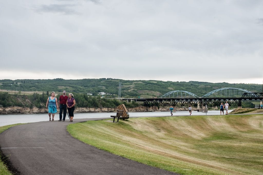
12 Foot Davis Events Park
While most of these stops let you enjoy the valley from above, this one lets you revel in nature from below. Tucked behind the Heritage Tower Lodge next to the Heart River is a natural amphitheatre which has been transformed into an events park. The park is accessed by a picturesque foot bridge over the Heart River—a favourite place for photo shoots. Beyond the park is an impressive trestle bridge. Grab the camera and capture the beauty of this hidden treasure.
How to get there:
Driving (1-5 minutes from anywhere downtown):
From Peace River Main Street (100 Street), go south until you reach 102 Avenue. Turn east (left), then south on 101 Street. Turn left on 103 Avenue, immediately after the Heart River Bridge. Drive to the end of the short road and park next to Heritage Towers. Walk across the foot bridge to visit the park.
Map app search terms: 12’ Events Park

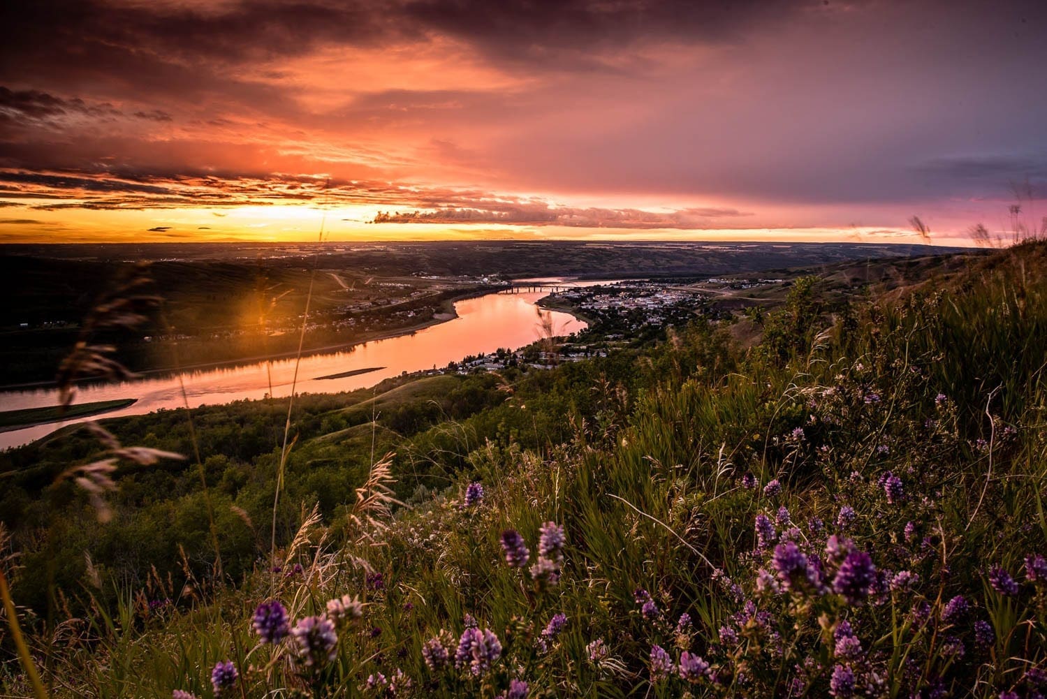
Sagitawa Lookout/Greene Valley Provincial Park
“Sagitawa” is derived from a Cree word meaning “where the rivers meet,” the name which describes the confluence of the Peace, Smokey, and Heart Rivers. This charming roadside turnout provides three picnic tables, an enclosed barbecue stand, and several benches in a wonderful day use area with a well-groomed lawn. Not to mention the view! There’s no better place to get an eyeful of both the Town of Peace River and the waterway it was named after. So grab some lunch and take the short drive to enjoy the view from the best seat in the valley.
How to get there:
Driving (5 minutes):
From 12 Foot Davis Events Park, drive back to 101 Street (Highway 744). Follow the signs for Highway 744/Judah Hill. The lookout is at the top of the valley on the right.
Local Explorer’s Tip: After you have finished enjoying the view of the Peace River Valley from the lookout, carefully cross the road to see the Greene Valley Provincial Park wildlife preserve on the other side. Don’t trust Google on this one—the point it marks leads nowhere you can explore.
Map app search terms: Sagitawa Lookout


