-
SavePlace Title: Manning Ski HillPlace Description:
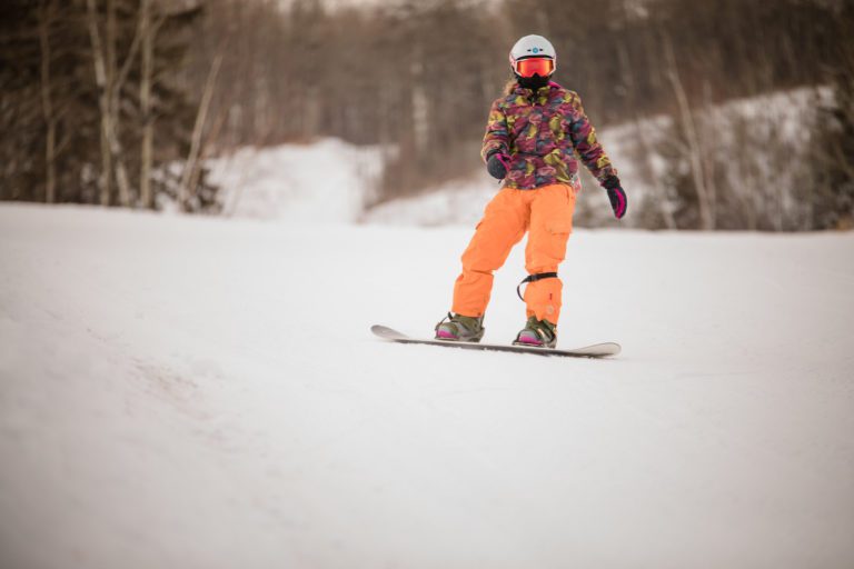
If you’re looking for affordable winter fun that the whole family can enjoy, then you MUST experience what the Manning Ski Hill has to offer!
The Manning and District Ski Club has been in operation since 1972 as a non-profit organization in the Notikewan River Valley, just east of the town of Manning. With some of the best scenery around, this hill is a favourite to many locals and out of town visitors. The hill itself has four main runs with a t-bar lift, making it easy to use for all ages. Whether you’re just started out on the slopes or are an experienced skier or snowboarder, this hill has something for everyone to enjoy.
Staying active during the winter season is important and the Manning Ski Club is committed to helping users do just that. Although they don’t offer lessons at this time, they do have a chalet with pre-packaged snacks to help visitors refuel after a long day hitting the slopes.
Northern Alberta Small Ski Area (NASSA) Passport
New! With the purchase of a season pass.
This passport entitles the season pass holder to 1 complimentary lift pass at each of the participating skills. The ski area will stamp your passport to indicate redemption. Return your completed passport, with stamps from all six ski areas to be entered into a draw at the end of the season. The passport is valid only during the season of purchase. A complimentary pass exclusion of liability waiver must be signed by an adult for each ski area at the time of redemption.Tags: Northern Lights WinterAddress: Range Road 224
Northern Lights No. 22
Alberta
CanadaEmail: skiclubmanning@gmail.comIf you’re looking for affordable winter fun that the whole family can enjoy, then you MUST experience what the Manning Ski Hill has to offer!
The Manning and District Ski Club has been in operation since 1972 as a non-profit organization in the Notikewan River Valley, just east of the town of Manning. With some of the best scenery around, this hill is a favourite to many locals and out of town visitors. The hill itself has four main runs with a t-bar lift, making it easy to use for all ages. Whether you’re just started out on the slopes or are an experienced skier or snowboarder, this hill has something for everyone to enjoy.
Staying active during the winter season is important and the Manning Ski Club is committed to helping users do just that. Although they don’t offer lessons at this time, they do have a chalet with pre-packaged snacks to help visitors refuel after a long day hitting the slopes.
Northern Alberta Small Ski Area (NASSA) Passport
New! With the purchase of a season pass.
This passport entitles the season pass holder to 1 complimentary lift pass at each of the participating skills. The ski area will stamp your passport to indicate redemption. Return your completed passport, with stamps from all six ski areas to be entered into a draw at the end of the season. The passport is valid only during the season of purchase. A complimentary pass exclusion of liability waiver must be signed by an adult for each ski area at the time of redemption.
- Be Picky
- Offers
- Do
- Tours
- All Circle Tours
- Agriculture Tour in the Mighty Peace
- 8-Day Northern Alberta RV Itinerary
- Golf Tour
- Geocache Tour
- Unique & Hidden Gems Tour
- The Great Northern Mighty Frontier Circle Tour
- The Great Northern Mighty Frontier Circle Tour – Mackenzie Frontier
- World Jet Boat Championship Circle Tour
- Northern Lights & Dark Sky Guide
- Summer Francophone Circle Tour
- Winter Francophone Circle Tour
- Stay
- Destinations
- Plan
- Signature Events
- Falher Honey Festival
- Fairview SOS Party
- Peace River Pow Wow
- World Jet Boat Championship Circle Tour
- Woodland Cree First Nation Treaty Days
- Wanham Plowing Match
- Bonanza Agricultural Fair & Mud Bogs
- Waterhole Rodeo
- Peace Mud Bogs & Fair
- Race The 8
- Summer’s End Festival
- Harvest Moon Festival
- Miserable Miles
- Town Of McLennan Oktoberfest
- Monthly
Contest - Members
- Be Picky
- Offers
- Do
- Tours
- Back
- All Circle Tours
- Agriculture Tour in the Mighty Peace
- 8-Day Northern Alberta RV Itinerary
- Golf Tour
- Geocache Tour
- Unique & Hidden Gems Tour
- The Great Northern Mighty Frontier Circle Tour
- The Great Northern Mighty Frontier Circle Tour – Mackenzie Frontier
- World Jet Boat Championship Circle Tour
- Northern Lights & Dark Sky Guide
- Summer Francophone Circle Tour
- Winter Francophone Circle Tour
- Stay
- Destinations
- Plan
- Signature Events
- Back
- Falher Honey Festival
- Fairview SOS Party
- Peace River Pow Wow
- World Jet Boat Championship Circle Tour
- Woodland Cree First Nation Treaty Days
- Wanham Plowing Match
- Bonanza Agricultural Fair & Mud Bogs
- Waterhole Rodeo
- Peace Mud Bogs & Fair
- Race The 8
- Summer’s End Festival
- Harvest Moon Festival
- Miserable Miles
- Town Of McLennan Oktoberfest
- Monthly
Contest - Members

