No Records Found
Sorry, no records were found. Please adjust your search criteria and try again.
Google Map Not Loaded
Sorry, unable to load Google Maps API.
-
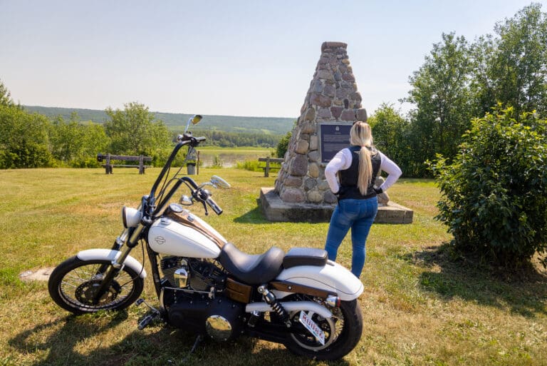
SavePlace Title: Fort Fork/Mackenzie CairnPlace Description:
Paddling furiously along the Peace River to beat freeze up, Alexander Mackenzie and his crew must have been very glad to reach the area where Fort Fork was to be built and where they were able to find shelter from the coming winter weather. Soon after his arrival Mackenzie observed “the river stopped” indicating freeze up had arrived! Mackenzie, a Scottish born explorer and fur trader was to spend the winter of 1792 – 93 at Fort Fork before continuing on his famed journey to the Pacific Ocean. Fort Fork was named for its close proximity to the convergence of the Smoky and Peace Rivers. The fort provided shelter for Mackenzie and several years later the explorer – geographer David Thompson. The fort was also the main North West Company post in the Peace Country until 1806 when its operations were moved to Fort Dunvegan. Stones from an original chimney in the fort have been preserved and fashioned into a fireplace for the public to view at the Peace River Museum, Archives and Mackenzie Centre.
Mackenzie Cairn, a National Historic site since 1929, was built to commemorate Fort Fork and marks the spot where visitors can look across the river to the approximate area of Fort Fork which has long since been erased by the ravages of time and river erosion. Mackenzie Cairn is found a short distance from the Town of Peace River, along the Shaftsbury Trail.
Tags: Circle TourAddress: On the Shaftesbury Trail
Peace River
Alberta
T8S 1X2
CanadaPaddling furiously along the Peace River to beat freeze up, Alexander Mackenzie and his crew must have been very glad to reach the area where Fort Fork was to be built and where they were able to find shelter from the coming winter weather. Soon after his arrival Mackenzie observed “the river stopped” indicating freeze up had arrived! Mackenzie, a Scottish born explorer and fur trader was to spend the winter of 1792 – 93 at Fort Fork before continuing on his famed journey to the Pacific Ocean. Fort Fork was named for its close proximity to the convergence of the Smoky and Peace Rivers. The fort provided shelter for Mackenzie and several years later the explorer – geographer David Thompson. The fort was also the main North West Company post in the Peace Country until 1806 when its operations were moved to Fort Dunvegan. Stones from an original chimney in the fort have been preserved and fashioned into a fireplace for the public to view at the Peace River Museum, Archives and Mackenzie Centre.
Mackenzie Cairn, a National Historic site since 1929, was built to commemorate Fort Fork and marks the spot where visitors can look across the river to the approximate area of Fort Fork which has long since been erased by the ravages of time and river erosion. Mackenzie Cairn is found a short distance from the Town of Peace River, along the Shaftsbury Trail.
-
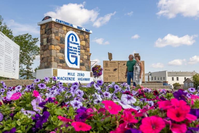
SavePlace Title: Mile Zero MarkerPlace Description:
Exploring Alberta’s North and beyond?
Be sure to stop in at the Mile Zero Marker in Grimshaw and get a photo! This monument which is part of the Tom Baldwin Memorial Arboretum and the Historic Mackenzie Highway Park, is easy to find, right off the main highway 2 going through the town of Grimshaw. The historic Northern Alberta Railway car beside the marker, offers another photo opportunity for visitors. The monument marks mile zero of the Mackenzie Highway that will lead visitors north to Manning, High Level, Hay River, Yellowknife and beyond.
Tags: Circle TourAddress: 5020 55th Avenue
Grimshaw
Alberta
T0H 1W0
CanadaExploring Alberta’s North and beyond?
Be sure to stop in at the Mile Zero Marker in Grimshaw and get a photo! This monument which is part of the Tom Baldwin Memorial Arboretum and the Historic Mackenzie Highway Park, is easy to find, right off the main highway 2 going through the town of Grimshaw. The historic Northern Alberta Railway car beside the marker, offers another photo opportunity for visitors. The monument marks mile zero of the Mackenzie Highway that will lead visitors north to Manning, High Level, Hay River, Yellowknife and beyond.
-
SavePlace Title: Dixonville Community Forest TrailPlace Description:
A magical gem of Boreal forest with easy access awaits you only 600 metres off of Highway 35. From highway 35, turn west onto highway 689 into the hamlet of Dixonville. Dixonville is approximately 57km northwest of the Town of Peace River. Once in Dixonville, watch carefully for 1st St. West and turn South on it. You will then come to a large truck parking lot on your right hand side. You have now arrived at your enchanted destination.
The entry to the forest trail is marked by a large sign with flags and is adjacent to a foot bridge. Cross over the bridge (beware of the old troll that may still be lurking) and you are onto the trail. The majority of the trail is a gravel surface and while not suited for a wheelchair, it is mostly flat and level. The trail is approximately 1.5km’s and offers a great way to stretch your legs while taking in the sights, sounds and smells of a typical boreal forest.
Along the trail you will find informative signs highlighting various aspects of the flora and fauna. A variety of bird houses and even bat houses have been installed throughout the forest to encourage nesting. For the young or very young at heart, look for a tiny enchanted forest but be very quiet as you never know what or who you may see in there. A side trail will have you bounding on soft moss and encompassed by some large White Spruce trees.
In the wintertime, the trails are still very much so accessible. The main portion of the trail is packed and groomed for easier walking or cross country skiing. The side loop is intentionally not groomed as it lends itself well to snowshoeing and off trail exploration.
A 50 metre section of the trail lovingly referred to as “Chickadee Alley”, features several large bird feeders complete with bins of seeds. Feel free to fill the feeders while you watch and listen. It is not unusual to feed over 600 pounds of seeds here each winter not to mention suet and other treats! These feeders are primarily stocked in winter months only. From spring months until late fall months our small forest critters are able to forage just fine within the vast hearty taiga.
Toilet facilities are not provided and campfires are only permitted in the Shady Lane campground located south of the Community Forest.
No OHVs permitted
Category: Circle Tour, Dark Sky Adventures, County of Northern Lights, Outdoors, Trails, and Winter ActivitiesAddress: 1 Street West, Dixonville
Dixonville
Alberta
CanadaTelephone Number: 780-836-3348A magical gem of Boreal forest with easy access awaits you only 600 metres off of Highway 35. From highway 35, turn west onto highway 689 into the hamlet of Dixonville. Dixonville is approximately 57km northwest of the Town of Peace River. Once in Dixonville, watch carefully for 1st St. West and turn South on it. You will then come to a large truck parking lot on your right hand side. You have now arrived at your enchanted destination.
The entry to the forest trail is marked by a large sign with flags and is adjacent to a foot bridge. Cross over the bridge (beware of the old troll that may still be lurking) and you are onto the trail. The majority of the trail is a gravel surface and while not suited for a wheelchair, it is mostly flat and level. The trail is approximately 1.5km’s and offers a great way to stretch your legs while taking in the sights, sounds and smells of a typical boreal forest.
Along the trail you will find informative signs highlighting various aspects of the flora and fauna. A variety of bird houses and even bat houses have been installed throughout the forest to encourage nesting. For the young or very young at heart, look for a tiny enchanted forest but be very quiet as you never know what or who you may see in there. A side trail will have you bounding on soft moss and encompassed by some large White Spruce trees.
In the wintertime, the trails are still very much so accessible. The main portion of the trail is packed and groomed for easier walking or cross country skiing. The side loop is intentionally not groomed as it lends itself well to snowshoeing and off trail exploration.
A 50 metre section of the trail lovingly referred to as “Chickadee Alley”, features several large bird feeders complete with bins of seeds. Feel free to fill the feeders while you watch and listen. It is not unusual to feed over 600 pounds of seeds here each winter not to mention suet and other treats! These feeders are primarily stocked in winter months only. From spring months until late fall months our small forest critters are able to forage just fine within the vast hearty taiga.
Toilet facilities are not provided and campfires are only permitted in the Shady Lane campground located south of the Community Forest.
No OHVs permitted
-
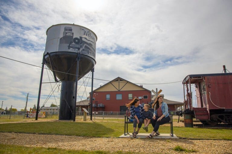
SavePlace Title: Nampa and District Museum and Tourist Information CenterPlace Description:
Explore the legendary Mighty Peace, from the fur trade to modern times, through the exhibits at our museum. Discover Nampa and Northern Sunrise County’s historic multicultural roots by following the steps of those who ventured to Canada’s northern-most homesteading area, across the Grouard Trail and onto the railways that took people from all over the world through muskeg to the Mighty Peace Country. Learn about local industries, about farming, about traditional ways as we guide you through the indoor and outdoor exhibits and buildings. With displays on two floors open year round and outdoor exhibits accessible from May to September, the Nampa and District Museum is more than worth a gander.
Major attractions include:
- The original water tank built by the Central Canada Railway to which Nampa owes its very own existence;
- Our old-time boardwalk of shops and businesses from the early to mid 1900’s;
- Our taxidermy exhibits, showing off local wildlife in the area
- The Rucka settlement house (circa 1937)
- Reno’s Ukrainian Catholic Church (circa 1946)
And so much more.
Hours of Operation
- June 1st to August 31st – 10 am to 5 pm / 7 days a week
- September 1st to May 31st – 10 am to 5 pm / Monday to Friday
- Admission: Seniors 65+ $3, Family $15, Adults $7, Students/children attending school $3, Children under 6 Free
Category: Agricultural, Arts & Culture, Circle Tour, Gift Shops & Other, Motorcycle Tours, Museums, Northern Sunrise County, Places To See, Shopping, Things To Do, and Village of NampaAddress: 9902 102 Avenue
Nampa
Alberta
T0H 2R0
CanadaTelephone Number: (780) 322-2777Email: nampamuseum@gmail.comExplore the legendary Mighty Peace, from the fur trade to modern times, through the exhibits at our museum. Discover Nampa and Northern Sunrise County’s historic multicultural roots by following the steps of those who ventured to Canada’s northern-most homesteading area, across the Grouard Trail and onto the railways that took people from all over the world through muskeg to the Mighty Peace Country. Learn about local industries, about farming, about traditional ways as we guide you through the indoor and outdoor exhibits and buildings. With displays on two floors open year round and outdoor exhibits accessible from May to September, the Nampa and District Museum is more than worth a gander.
Major attractions include:
- The original water tank built by the Central Canada Railway to which Nampa owes its very own existence;
- Our old-time boardwalk of shops and businesses from the early to mid 1900’s;
- Our taxidermy exhibits, showing off local wildlife in the area
- The Rucka settlement house (circa 1937)
- Reno’s Ukrainian Catholic Church (circa 1946)
And so much more.
Hours of Operation
- June 1st to August 31st – 10 am to 5 pm / 7 days a week
- September 1st to May 31st – 10 am to 5 pm / Monday to Friday
- Admission: Seniors 65+ $3, Family $15, Adults $7, Students/children attending school $3, Children under 6 Free
-
SavePlace Title: Figure Eight LakePlace Description:
Figure Eight Lake Provincial Recreation Area is located 40 kilometers northwest of Peace River on Highway 737 in the County of Northern Lights. Figure Eight Lake takes its name from the shape it had before 1970 when the water level was low, in these earlier days the lake had two basins and resembled a figure eight.
Get There: Figure 8 Lake is 45 km west of Peace River on Highway 737.
GPS Lat/Long:
56.3007800, -117.909248
Category: Accommodations, Campgrounds, Circle Tour, Dark Sky Adventures, County of Northern Lights, and Parks & LakesAddress: Located 8 kilometers north of Grimshaw, then 20 km west on Highway 737.
MD of Peace
Alberta
T0H 1E0
CanadaTelephone Number: (780) 624-6486Figure Eight Lake Provincial Recreation Area is located 40 kilometers northwest of Peace River on Highway 737 in the County of Northern Lights. Figure Eight Lake takes its name from the shape it had before 1970 when the water level was low, in these earlier days the lake had two basins and resembled a figure eight.
Get There: Figure 8 Lake is 45 km west of Peace River on Highway 737.
GPS Lat/Long:
56.3007800, -117.909248
-
SavePlace Title: Nampa Sunrise CaféPlace Description:
Conveniently located off the main highway in Nampa, the Nampa Sunrise Café is a one stop shop for mouthwatering meals, tantalizing treats, tasty appetizers, and so much more. With a wide range of menu items to pick from, you can choose from things such as freshly made salads, loaded burgers, donairs, quesadillas, fish tacos, pierogi platters, and even poutine. Extremely family friendly, they even have a large table equipped with a scavenger hunt for kids to enjoy. This bright, welcoming café is ready to provide you with great customer service and a cozy atmosphere to enjoy your next meal away from home. Stop in today and experience what they have to offer!
Category: Agricultural, Circle Tour, Entertainment & Nightlife, Farm Fresh Foods, Food & Drink, and Village of NampaAddress: 9902 102 Ave
Village of Nampa
Alberta
T0H 2R0
CanadaTelephone Number: (780) 322-2032Email: nampasunrisecafe@icloud.comConveniently located off the main highway in Nampa, the Nampa Sunrise Café is a one stop shop for mouthwatering meals, tantalizing treats, tasty appetizers, and so much more. With a wide range of menu items to pick from, you can choose from things such as freshly made salads, loaded burgers, donairs, quesadillas, fish tacos, pierogi platters, and even poutine. Extremely family friendly, they even have a large table equipped with a scavenger hunt for kids to enjoy. This bright, welcoming café is ready to provide you with great customer service and a cozy atmosphere to enjoy your next meal away from home. Stop in today and experience what they have to offer!
-
SavePlace Title: Sagitawa LookoutPlace Description:
The Sagitawa Lookout is located just south of the Town of Peace River on Hwy 744 in Northern Sunrise County. Sagitawa is a Cree word meaning “Where the rivers meet”. The Lookout has a spectacular view of the Town of Peace River and the confluence of the Peace, Smoky and Heart rivers. The Lookout is complete with picnic area and historical information.
Directions from Main Street Peace River:
Drive down Main Street ( 100 Street) to the bottom of Main, then turn left onto 102 Avenue. Follow this to 102 Avenue, turn right and cross the Heart River bridge. Turn left onto 104 Avenue and follow the Hwy 744 signs. The Lookout is located up the “Judah Hill”. Watch for lookout signage.
Category: Circle Tour, Northern Sunrise County, Outdoors, Places To See, Sights & Experiences, and Things To DoTags: Circle TourAddress: Alberta 744
Marie-Reine
Alberta
T0H 2N0
CanadaThe Sagitawa Lookout is located just south of the Town of Peace River on Hwy 744 in Northern Sunrise County. Sagitawa is a Cree word meaning “Where the rivers meet”. The Lookout has a spectacular view of the Town of Peace River and the confluence of the Peace, Smoky and Heart rivers. The Lookout is complete with picnic area and historical information.
Directions from Main Street Peace River:
Drive down Main Street ( 100 Street) to the bottom of Main, then turn left onto 102 Avenue. Follow this to 102 Avenue, turn right and cross the Heart River bridge. Turn left onto 104 Avenue and follow the Hwy 744 signs. The Lookout is located up the “Judah Hill”. Watch for lookout signage.
-
SavePlace Title: Shaftesbury Trail & FerryPlace Description:
Enjoy the beauty of the Peace River and it’s valley by taking the short drive down the Shaftesbury Trail!
Running along side the Mighty Peace River for approximately 26km, the Shaftesbury Trail is one of the most scenic and interesting drives in the Peace region. Originally used by First Nations and Metis fur traders it is the location of several important historic sites. Start your tour on this paved and well maintained roadway either from Grimshaw going south on Highway 2, then taking secondary Highway 684 down into the valley or from Peace River, turn onto Highway 684, which can be accessed on the west side of the Peace River bridge. A relaxing and interesting adventure awaits! Along the way visit Fort Fork, MacKenzie Cairn as well as St. Augustine’s Mission. Stop for a picnic at Strong Creek Park and enjoy the stunning scenery and abundant wildlife! Continue on and visit the market gardens to see what’s in season! End your Shaftsbury Trail adventure with a ride on the Shaftesbury Ferry, the view of the river and surrounding hills is spectacular!
Getting There
From Grimshaw: go south on Highway 2, then take secondary Highway 684 down into the valley. From Peace River: turn onto Highway 684, which can be accessed on the west side of the Peace River bridge.
Mackenzie Cairn
It was 1793 when Sir Alexander Mackenzie, famed North American explorer, overwintered at Fort Fork before starting his transcontinental journey to the Pacific. The Mackenzie Cairn, built in 1929, honours both the Fort Fork trading post and the place where Mackenzie’s important journey began. This National Historic Site also provides a wonderful view of the Peace River, and an information kiosk offers detailed maps, drawings of the fort and early photos. Historic tours are available during the summer months.St. Augustine Mission Church
About 13 km southwest of the Town of Peace River, the St. Augustine Mission Church sits in a tranquil space in the valley. A Provincial Historic Site, St. Augustine Mission Church is the remains of the St. Augustine Mission, established in 1888. Tours of the church and grounds are available in the summer.Bridgeview Gardens
U-Pick berries and other vegetables. Call them at 780-624-1335.Fort McLeod
A historical site on the banks of the Peace River. Learn more about fur trade history with new interpretive signs, or visit the Peace River Museum, Archives and Mackenzie Centre for a more in-depth history.Strong Creek Park
Free camping, kitchen shelter, water, fishing, hiking trails and playground, including a backstop and field for baseball/softball.Brick’s Hill
When driving from Hwy 2 near Grimshaw, take Brick’s Hill to take in the beauty of the valley floor. Named after original families owning river lots in the area, Brick’s Hill boasts an abundant landscape of agriculture and gardens. The hills are layered with history and evidence of the Cree and Beaver First Nations.Shaftesbury Ferry
A unique experience awaits at the Shaftesbury Ferry!This is one of only 6 ferries operated by Alberta Transportation in the entire province! The ferry is part of highway 740 and crosses the mighty Peace River linking the Shaftesbury Trail with the Tangent Park area. The length of the crossing is 325 metres and takes about 5 minutes. Enjoy spectacular river valley scenery during the crossing and keep your eyes open for the abundant wildlife that frequent this area. This experience is available May through the end of October, 7am to 11pm daily. The ferry is free of charge and can accommodate everything from foot traffic to large RV’s and motorcycles. Visit 511 Alberta for the most recent information about ferry operations.
Tangent Park
Tangent Park campground is located on the east bank of the river, just a ferry ride across from the Shaftesbury Trail. It offers full service sites, showers, group camping and horseback riding/hiking trails.Category: Circle Tour, Getting Here, Mighty Peace Essentials, Town of Peace River, M.D. of Peace, Sights & Experiences, and Things To DoAddress: 11510 Shaftesbury Trail
Peace River
Alberta
T8S 1P7
CanadaEnjoy the beauty of the Peace River and it’s valley by taking the short drive down the Shaftesbury Trail!
Running along side the Mighty Peace River for approximately 26km, the Shaftesbury Trail is one of the most scenic and interesting drives in the Peace region. Originally used by First Nations and Metis fur traders it is the location of several important historic sites. Start your tour on this paved and well maintained roadway either from Grimshaw going south on Highway 2, then taking secondary Highway 684 down into the valley or from Peace River, turn onto Highway 684, which can be accessed on the west side of the Peace River bridge. A relaxing and interesting adventure awaits! Along the way visit Fort Fork, MacKenzie Cairn as well as St. Augustine’s Mission. Stop for a picnic at Strong Creek Park and enjoy the stunning scenery and abundant wildlife! Continue on and visit the market gardens to see what’s in season! End your Shaftsbury Trail adventure with a ride on the Shaftesbury Ferry, the view of the river and surrounding hills is spectacular!
Getting There
From Grimshaw: go south on Highway 2, then take secondary Highway 684 down into the valley. From Peace River: turn onto Highway 684, which can be accessed on the west side of the Peace River bridge.
Mackenzie Cairn
It was 1793 when Sir Alexander Mackenzie, famed North American explorer, overwintered at Fort Fork before starting his transcontinental journey to the Pacific. The Mackenzie Cairn, built in 1929, honours both the Fort Fork trading post and the place where Mackenzie’s important journey began. This National Historic Site also provides a wonderful view of the Peace River, and an information kiosk offers detailed maps, drawings of the fort and early photos. Historic tours are available during the summer months.St. Augustine Mission Church
About 13 km southwest of the Town of Peace River, the St. Augustine Mission Church sits in a tranquil space in the valley. A Provincial Historic Site, St. Augustine Mission Church is the remains of the St. Augustine Mission, established in 1888. Tours of the church and grounds are available in the summer.Bridgeview Gardens
U-Pick berries and other vegetables. Call them at 780-624-1335.Fort McLeod
A historical site on the banks of the Peace River. Learn more about fur trade history with new interpretive signs, or visit the Peace River Museum, Archives and Mackenzie Centre for a more in-depth history.Strong Creek Park
Free camping, kitchen shelter, water, fishing, hiking trails and playground, including a backstop and field for baseball/softball.Brick’s Hill
When driving from Hwy 2 near Grimshaw, take Brick’s Hill to take in the beauty of the valley floor. Named after original families owning river lots in the area, Brick’s Hill boasts an abundant landscape of agriculture and gardens. The hills are layered with history and evidence of the Cree and Beaver First Nations.Shaftesbury Ferry
A unique experience awaits at the Shaftesbury Ferry!This is one of only 6 ferries operated by Alberta Transportation in the entire province! The ferry is part of highway 740 and crosses the mighty Peace River linking the Shaftesbury Trail with the Tangent Park area. The length of the crossing is 325 metres and takes about 5 minutes. Enjoy spectacular river valley scenery during the crossing and keep your eyes open for the abundant wildlife that frequent this area. This experience is available May through the end of October, 7am to 11pm daily. The ferry is free of charge and can accommodate everything from foot traffic to large RV’s and motorcycles. Visit 511 Alberta for the most recent information about ferry operations.
Tangent Park
Tangent Park campground is located on the east bank of the river, just a ferry ride across from the Shaftesbury Trail. It offers full service sites, showers, group camping and horseback riding/hiking trails. -
SavePlace Title: Strong Creek ParkPlace Description:
Tucked along the banks of the Peace River in the MD of Peace, Strong Creek Campground is a year-round escape for outdoor lovers. Located just 8 km south of Peace River on the scenic Shaftesbury Trail, this rustic campground offers an affordable stay at only $20 per night. Enjoy the convenience of washrooms, potable water, and a sheltered kitchen while still feeling close to nature.
In summer, spend your days soaking up the sun, paddling, or casting a line in the Peace River—just a short stroll from your campsite. The park also features picnic tables, a playground for the kids, and hiking trails that wind through the area’s natural beauty.
When winter arrives, Strong Creek transforms into a snowy retreat perfect for snowshoeing and crisp winter hikes. The playground remains a family favourite year-round, and firepits invite you to gather for cozy outdoor picnics.
Location: Approximately 12.5 km southeast of Peace River along Highway #684.
Category: Accommodations, Boating, On the Peace River, Campgrounds, Circle Tour, Outdoors, Parks & Lakes, M.D. of Peace, and Sights & ExperiencesAddress: Alberta 684
Grimshaw
Alberta
T0H 1W0
CanadaTelephone Number: 780-338-3845Tucked along the banks of the Peace River in the MD of Peace, Strong Creek Campground is a year-round escape for outdoor lovers. Located just 8 km south of Peace River on the scenic Shaftesbury Trail, this rustic campground offers an affordable stay at only $20 per night. Enjoy the convenience of washrooms, potable water, and a sheltered kitchen while still feeling close to nature.
In summer, spend your days soaking up the sun, paddling, or casting a line in the Peace River—just a short stroll from your campsite. The park also features picnic tables, a playground for the kids, and hiking trails that wind through the area’s natural beauty.
When winter arrives, Strong Creek transforms into a snowy retreat perfect for snowshoeing and crisp winter hikes. The playground remains a family favourite year-round, and firepits invite you to gather for cozy outdoor picnics.
Location: Approximately 12.5 km southeast of Peace River along Highway #684.
-
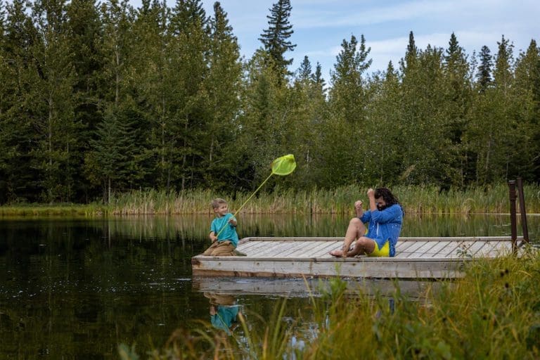
SavePlace Title: Wilderness ParkPlace Description:
Searching for a back to nature experience?
Head out to the Wilderness Park located approximately 11km west of Peace River; the path into the area is as beautiful as the park itself! This day use area has picnic tables, fire pits, outhouses and man-made ponds to enjoy! Swimming is not allowed but fishing enthusiasts bring your fishing rods as the ponds are stocked with rainbow trout and grayling! There are docks to fish from and to launch your canoe, kayak or paddle board. Hiking trails abound in the area, part of which include the Trans Canada Trail! Bring your binoculars and enjoy some bird watching, this area is abundant with wildlife. A crackling campfire is the perfect end to a day of fun at Wilderness Park! Please reduce visitor’s impact on the park by taking your garbage home with you. Park closes at 11pm.
Category: Accommodations, Circle Tour, Dark Sky Adventures, Outdoors, Parks & Lakes, M.D. of Peace, Sights & Experiences, Trails, and Winter ActivitiesAddress: Grimshaw
Grimshaw
Alberta
T0H
CanadaSearching for a back to nature experience?
Head out to the Wilderness Park located approximately 11km west of Peace River; the path into the area is as beautiful as the park itself! This day use area has picnic tables, fire pits, outhouses and man-made ponds to enjoy! Swimming is not allowed but fishing enthusiasts bring your fishing rods as the ponds are stocked with rainbow trout and grayling! There are docks to fish from and to launch your canoe, kayak or paddle board. Hiking trails abound in the area, part of which include the Trans Canada Trail! Bring your binoculars and enjoy some bird watching, this area is abundant with wildlife. A crackling campfire is the perfect end to a day of fun at Wilderness Park! Please reduce visitor’s impact on the park by taking your garbage home with you. Park closes at 11pm.