No Records Found
Sorry, no records were found. Please adjust your search criteria and try again.
Google Map Not Loaded
Sorry, unable to load Google Maps API.
-
SavePlace Title: Historic Dunvegan Provincial ParkPlace Description:
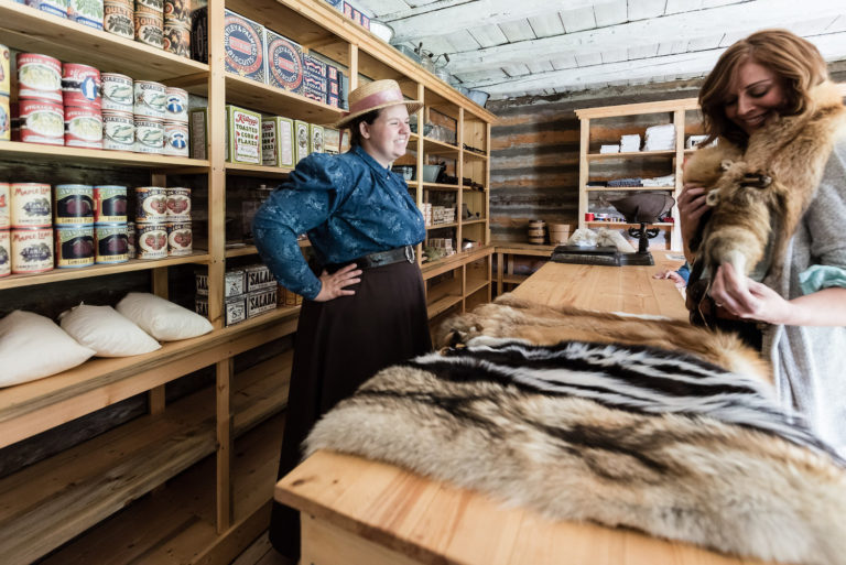
Historic Dunvegan is a provincially and nationally designated historic resource. Experience history through 4 original, authentically restored and furnished buildings and the stories of Indigenous, fur trade, and mission life that our historic interpreters are waiting to share with you. Located alongside the Peace River with a breathtaking view of Alberta’s longest vehicle suspension bridge, there are activities for the whole family! A visitors’ centre located near the entrance offers information as well as guided tours of the historic buildings. The Visitor Centre and historic buildings are open from May 18 through Labour Day, 10am-5pm Wednesday through Sunday and holiday Mondays. Admission fees apply.
2024 Special Events
Dunvegan Tsattine/Beaver Storytelling – June 22, 1pm
Canada Day – July 1, Noon-5pm
Fresh Air Market – August 4, 11-5pm
Sunday Funday – May 19 and June 30, 10am-5pm
Picnic in the Park – July 14 and August 11, 11am-3pmLocated 26km south of Fairview on Highway 2. For more information please visit www.historicdunvegan.ca or find us on Facebook by searching @historicdunvegan!
Other nearby amenities include a day use area and campground operated by Alberta Parks. A playground, fire pits, cook shelters, and horseshoe pitches are all available. The Maples Day use area is just down the road, and offers a picnic shelter, fire pits, and a playground. You can also stroll down to the neighbouring Dunvegan Market Gardens for ice cream, food, shopping, and mini golf!
Category: Arts & Culture, Attractions, On the Peace River, Dark Sky Adventures, District of Fairview, Guided Adventure, Mighty Peace Essentials, Motorcycle Tours, Museums, Places To See, Sights & Experiences, and Things To DoAddress: Township Rd 801A
md of fairview
Alberta
T0H 0L0
CanadaTelephone Number: 780-835-7150Email: Historic.Dunvegan@gov.ab.caHistoric Dunvegan is a provincially and nationally designated historic resource. Experience history through 4 original, authentically restored and furnished buildings and the stories of Indigenous, fur trade, and mission life that our historic interpreters are waiting to share with you. Located alongside the Peace River with a breathtaking view of Alberta’s longest vehicle suspension bridge, there are activities for the whole family! A visitors’ centre located near the entrance offers information as well as guided tours of the historic buildings. The Visitor Centre and historic buildings are open from May 18 through Labour Day, 10am-5pm Wednesday through Sunday and holiday Mondays. Admission fees apply.
2024 Special Events
Dunvegan Tsattine/Beaver Storytelling – June 22, 1pm
Canada Day – July 1, Noon-5pm
Fresh Air Market – August 4, 11-5pm
Sunday Funday – May 19 and June 30, 10am-5pm
Picnic in the Park – July 14 and August 11, 11am-3pmLocated 26km south of Fairview on Highway 2. For more information please visit www.historicdunvegan.ca or find us on Facebook by searching @historicdunvegan!
Other nearby amenities include a day use area and campground operated by Alberta Parks. A playground, fire pits, cook shelters, and horseshoe pitches are all available. The Maples Day use area is just down the road, and offers a picnic shelter, fire pits, and a playground. You can also stroll down to the neighbouring Dunvegan Market Gardens for ice cream, food, shopping, and mini golf!
-
SavePlace Title: Hive HeroPlace Description:
Hive Hero’s, Valley Bee Café is a “sweet” place to visit; it boasts an observation window into the honey extraction room, an observation hive, a larger than life mural, bee facility tours, a community word search, handmade journals, and plenty of other goods created by local artisans. The community tables invite conversation and connection, giving visitors the opportunity to meet new people and also run into old friends.
People of all ages come to explore the world of bee year round!
WHAT MAKES THE HIVE HERO AND THE VALLEY BEE CAFÉ UNIQUE FROM ANY OTHER PLACE IN THE MIGHTY PEACE?
The way we’ve curated our education process allows people to entertain themselves and their families for hours. It’s a special experience to be able to see the inner workings of a beehive and watch the work of beekeepers being done first hand . The curious nature of our guests make this a place people can keep coming back to for a fresh experience each time. Like the inner workings of a hive we are always buzzing with something new!
Category: Agricultural, Farm Fresh Foods, Food & Drink, Gift Shops & Other, Made in the Mighty Peace, Motorcycle Tours, and Sights & ExperiencesTags: Circle Tour ContestAddress: 242009 TWP RD 779
Watino
Alberta
T0H 3J0
CanadaTelephone Number: 1-866-624-8175Email: info@paradisvalleyhoney.comHive Hero’s, Valley Bee Café is a “sweet” place to visit; it boasts an observation window into the honey extraction room, an observation hive, a larger than life mural, bee facility tours, a community word search, handmade journals, and plenty of other goods created by local artisans. The community tables invite conversation and connection, giving visitors the opportunity to meet new people and also run into old friends.
People of all ages come to explore the world of bee year round!
WHAT MAKES THE HIVE HERO AND THE VALLEY BEE CAFÉ UNIQUE FROM ANY OTHER PLACE IN THE MIGHTY PEACE?
The way we’ve curated our education process allows people to entertain themselves and their families for hours. It’s a special experience to be able to see the inner workings of a beehive and watch the work of beekeepers being done first hand . The curious nature of our guests make this a place people can keep coming back to for a fresh experience each time. Like the inner workings of a hive we are always buzzing with something new!
-
SavePlace Title: Judah HillPlace Description:
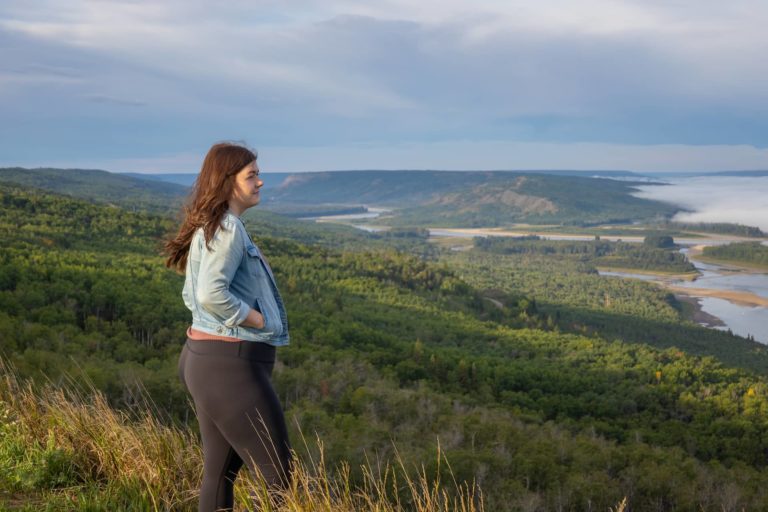
Judah Hill provides stunning views of the Land of the Mighty Peace and leads to one of Peace River’s most incredible and historical lookout points – Sagitawa Lookout.
Get There: Drive down Main Street (100 Street) to the bottom of Main, then turn left onto 102 Avenue. Follow this to 102 Avenue, turn right and cross the Heart River bridge. Turn left onto 104 Avenue and follow the Hwy 744 signs.
Address: Judah Hill Road, South End
Peace River
Peace River
T8S 1Y7
CanadaJudah Hill provides stunning views of the Land of the Mighty Peace and leads to one of Peace River’s most incredible and historical lookout points – Sagitawa Lookout.
Get There: Drive down Main Street (100 Street) to the bottom of Main, then turn left onto 102 Avenue. Follow this to 102 Avenue, turn right and cross the Heart River bridge. Turn left onto 104 Avenue and follow the Hwy 744 signs.
-
SavePlace Title: Sagitawa LookoutPlace Description:
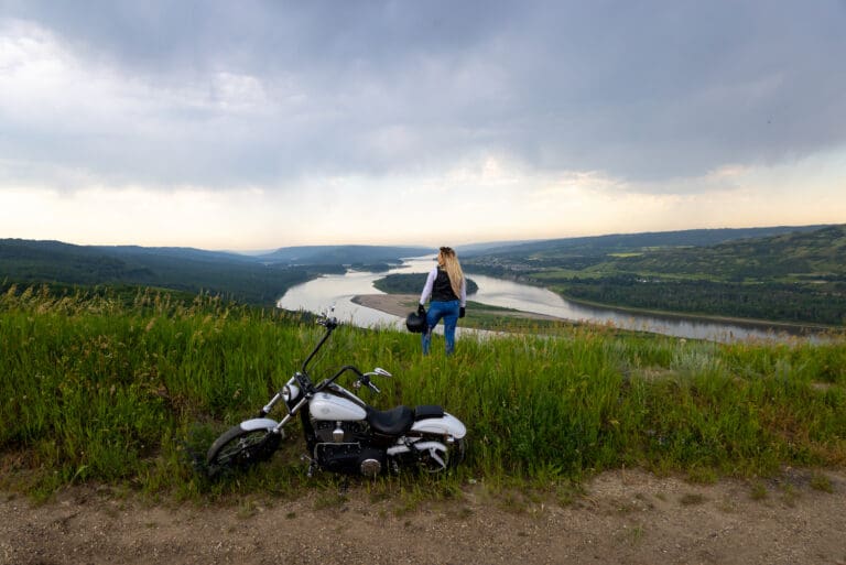
The Sagitawa Lookout is located just south of the Town of Peace River on Hwy 744 in Northern Sunrise County. Sagitawa is a Cree word meaning “Where the rivers meet”. The Lookout has a spectacular view of the Town of Peace River and the confluence of the Peace, Smoky and Heart rivers. The Lookout is complete with picnic area and historical information.
Directions from Main Street Peace River:
Drive down Main Street ( 100 Street) to the bottom of Main, then turn left onto 102 Avenue. Follow this to 102 Avenue, turn right and cross the Heart River bridge. Turn left onto 104 Avenue and follow the Hwy 744 signs. The Lookout is located up the “Judah Hill”. Watch for lookout signage.
Category: Circle Tour, Northern Sunrise County, Outdoors, Places To See, Sights & Experiences, and Things To DoTags: Circle TourAddress: Alberta 744
Marie-Reine
Alberta
T0H 2N0
CanadaThe Sagitawa Lookout is located just south of the Town of Peace River on Hwy 744 in Northern Sunrise County. Sagitawa is a Cree word meaning “Where the rivers meet”. The Lookout has a spectacular view of the Town of Peace River and the confluence of the Peace, Smoky and Heart rivers. The Lookout is complete with picnic area and historical information.
Directions from Main Street Peace River:
Drive down Main Street ( 100 Street) to the bottom of Main, then turn left onto 102 Avenue. Follow this to 102 Avenue, turn right and cross the Heart River bridge. Turn left onto 104 Avenue and follow the Hwy 744 signs. The Lookout is located up the “Judah Hill”. Watch for lookout signage.
-
SavePlace Title: Shaftesbury Trail & FerryPlace Description:
Enjoy the beauty of the Peace River and it’s valley by taking the short drive down the Shaftesbury Trail!
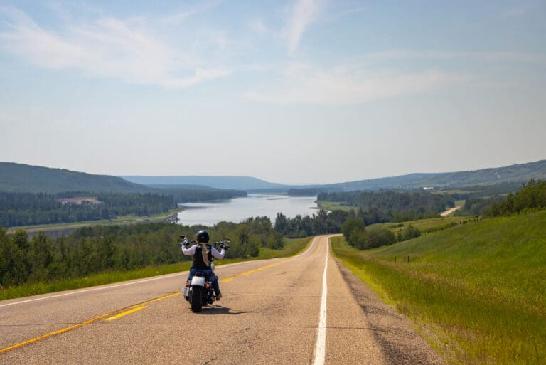
Running along side the Mighty Peace River for approximately 26km, the Shaftesbury Trail is one of the most scenic and interesting drives in the Peace region. Originally used by First Nations and Metis fur traders it is the location of several important historic sites. Start your tour on this paved and well maintained roadway either from Grimshaw going south on Highway 2, then taking secondary Highway 684 down into the valley or from Peace River, turn onto Highway 684, which can be accessed on the west side of the Peace River bridge. A relaxing and interesting adventure awaits! Along the way visit Fort Fork, MacKenzie Cairn as well as St. Augustine’s Mission. Stop for a picnic at Strong Creek Park and enjoy the stunning scenery and abundant wildlife! Continue on and visit the market gardens to see what’s in season! End your Shaftsbury Trail adventure with a ride on the Shaftesbury Ferry, the view of the river and surrounding hills is spectacular!
Getting There
From Grimshaw: go south on Highway 2, then take secondary Highway 684 down into the valley. From Peace River: turn onto Highway 684, which can be accessed on the west side of the Peace River bridge.
Mackenzie Cairn
It was 1793 when Sir Alexander Mackenzie, famed North American explorer, overwintered at Fort Fork before starting his transcontinental journey to the Pacific. The Mackenzie Cairn, built in 1929, honours both the Fort Fork trading post and the place where Mackenzie’s important journey began. This National Historic Site also provides a wonderful view of the Peace River, and an information kiosk offers detailed maps, drawings of the fort and early photos. Historic tours are available during the summer months.St. Augustine Mission Church
About 13 km southwest of the Town of Peace River, the St. Augustine Mission Church sits in a tranquil space in the valley. A Provincial Historic Site, St. Augustine Mission Church is the remains of the St. Augustine Mission, established in 1888. Tours of the church and grounds are available in the summer.Bridgeview Gardens
U-Pick berries and other vegetables. Call them at 780-624-1335.Fort McLeod
A historical site on the banks of the Peace River. Learn more about fur trade history with new interpretive signs, or visit the Peace River Museum, Archives and Mackenzie Centre for a more in-depth history.Strong Creek Park
Free camping, kitchen shelter, water, fishing, hiking trails and playground, including a backstop and field for baseball/softball.Brick’s Hill
When driving from Hwy 2 near Grimshaw, take Brick’s Hill to take in the beauty of the valley floor. Named after original families owning river lots in the area, Brick’s Hill boasts an abundant landscape of agriculture and gardens. The hills are layered with history and evidence of the Cree and Beaver First Nations.Shaftesbury Ferry
A unique experience awaits at the Shaftesbury Ferry!This is one of only 6 ferries operated by Alberta Transportation in the entire province! The ferry is part of highway 740 and crosses the mighty Peace River linking the Shaftesbury Trail with the Tangent Park area. The length of the crossing is 325 metres and takes about 5 minutes. Enjoy spectacular river valley scenery during the crossing and keep your eyes open for the abundant wildlife that frequent this area. This experience is available May through the end of October, 7am to 11pm daily. The ferry is free of charge and can accommodate everything from foot traffic to large RV’s and motorcycles. Visit 511 Alberta for the most recent information about ferry operations.
Tangent Park
Tangent Park campground is located on the east bank of the river, just a ferry ride across from the Shaftesbury Trail. It offers full service sites, showers, group camping and horseback riding/hiking trails.Category: Circle Tour, Getting Here, Mighty Peace Essentials, Town of Peace River, M.D. of Peace, Sights & Experiences, and Things To DoAddress: 11510 Shaftesbury Trail
Peace River
Alberta
T8S 1P7
CanadaEnjoy the beauty of the Peace River and it’s valley by taking the short drive down the Shaftesbury Trail!
Running along side the Mighty Peace River for approximately 26km, the Shaftesbury Trail is one of the most scenic and interesting drives in the Peace region. Originally used by First Nations and Metis fur traders it is the location of several important historic sites. Start your tour on this paved and well maintained roadway either from Grimshaw going south on Highway 2, then taking secondary Highway 684 down into the valley or from Peace River, turn onto Highway 684, which can be accessed on the west side of the Peace River bridge. A relaxing and interesting adventure awaits! Along the way visit Fort Fork, MacKenzie Cairn as well as St. Augustine’s Mission. Stop for a picnic at Strong Creek Park and enjoy the stunning scenery and abundant wildlife! Continue on and visit the market gardens to see what’s in season! End your Shaftsbury Trail adventure with a ride on the Shaftesbury Ferry, the view of the river and surrounding hills is spectacular!
Getting There
From Grimshaw: go south on Highway 2, then take secondary Highway 684 down into the valley. From Peace River: turn onto Highway 684, which can be accessed on the west side of the Peace River bridge.
Mackenzie Cairn
It was 1793 when Sir Alexander Mackenzie, famed North American explorer, overwintered at Fort Fork before starting his transcontinental journey to the Pacific. The Mackenzie Cairn, built in 1929, honours both the Fort Fork trading post and the place where Mackenzie’s important journey began. This National Historic Site also provides a wonderful view of the Peace River, and an information kiosk offers detailed maps, drawings of the fort and early photos. Historic tours are available during the summer months.St. Augustine Mission Church
About 13 km southwest of the Town of Peace River, the St. Augustine Mission Church sits in a tranquil space in the valley. A Provincial Historic Site, St. Augustine Mission Church is the remains of the St. Augustine Mission, established in 1888. Tours of the church and grounds are available in the summer.Bridgeview Gardens
U-Pick berries and other vegetables. Call them at 780-624-1335.Fort McLeod
A historical site on the banks of the Peace River. Learn more about fur trade history with new interpretive signs, or visit the Peace River Museum, Archives and Mackenzie Centre for a more in-depth history.Strong Creek Park
Free camping, kitchen shelter, water, fishing, hiking trails and playground, including a backstop and field for baseball/softball.Brick’s Hill
When driving from Hwy 2 near Grimshaw, take Brick’s Hill to take in the beauty of the valley floor. Named after original families owning river lots in the area, Brick’s Hill boasts an abundant landscape of agriculture and gardens. The hills are layered with history and evidence of the Cree and Beaver First Nations.Shaftesbury Ferry
A unique experience awaits at the Shaftesbury Ferry!This is one of only 6 ferries operated by Alberta Transportation in the entire province! The ferry is part of highway 740 and crosses the mighty Peace River linking the Shaftesbury Trail with the Tangent Park area. The length of the crossing is 325 metres and takes about 5 minutes. Enjoy spectacular river valley scenery during the crossing and keep your eyes open for the abundant wildlife that frequent this area. This experience is available May through the end of October, 7am to 11pm daily. The ferry is free of charge and can accommodate everything from foot traffic to large RV’s and motorcycles. Visit 511 Alberta for the most recent information about ferry operations.
Tangent Park
Tangent Park campground is located on the east bank of the river, just a ferry ride across from the Shaftesbury Trail. It offers full service sites, showers, group camping and horseback riding/hiking trails. -
SavePlace Title: Strong Creek ParkPlace Description:
Tucked along the banks of the Peace River in the MD of Peace, Strong Creek Campground is a year-round escape for outdoor lovers. Located just 8 km south of Peace River on the scenic Shaftesbury Trail, this rustic campground offers an affordable stay at only $20 per night. Enjoy the convenience of washrooms, potable water, and a sheltered kitchen while still feeling close to nature.
In summer, spend your days soaking up the sun, paddling, or casting a line in the Peace River—just a short stroll from your campsite. The park also features picnic tables, a playground for the kids, and hiking trails that wind through the area’s natural beauty.
When winter arrives, Strong Creek transforms into a snowy retreat perfect for snowshoeing and crisp winter hikes. The playground remains a family favourite year-round, and firepits invite you to gather for cozy outdoor picnics.
Location: Approximately 12.5 km southeast of Peace River along Highway #684.
Category: Accommodations, Boating, On the Peace River, Campgrounds, Circle Tour, Outdoors, Parks & Lakes, M.D. of Peace, and Sights & ExperiencesAddress: Alberta 684
Grimshaw
Alberta
T0H 1W0
CanadaTelephone Number: 780-338-3845Tucked along the banks of the Peace River in the MD of Peace, Strong Creek Campground is a year-round escape for outdoor lovers. Located just 8 km south of Peace River on the scenic Shaftesbury Trail, this rustic campground offers an affordable stay at only $20 per night. Enjoy the convenience of washrooms, potable water, and a sheltered kitchen while still feeling close to nature.
In summer, spend your days soaking up the sun, paddling, or casting a line in the Peace River—just a short stroll from your campsite. The park also features picnic tables, a playground for the kids, and hiking trails that wind through the area’s natural beauty.
When winter arrives, Strong Creek transforms into a snowy retreat perfect for snowshoeing and crisp winter hikes. The playground remains a family favourite year-round, and firepits invite you to gather for cozy outdoor picnics.
Location: Approximately 12.5 km southeast of Peace River along Highway #684.
-
SavePlace Title: Wilderness ParkPlace Description:
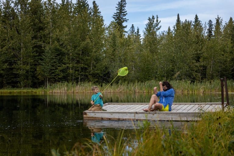
Searching for a back to nature experience?
Head out to the Wilderness Park located approximately 11km west of Peace River; the path into the area is as beautiful as the park itself! This day use area has picnic tables, fire pits, outhouses and man-made ponds to enjoy! Swimming is not allowed but fishing enthusiasts bring your fishing rods as the ponds are stocked with rainbow trout and grayling! There are docks to fish from and to launch your canoe, kayak or paddle board. Hiking trails abound in the area, part of which include the Trans Canada Trail! Bring your binoculars and enjoy some bird watching, this area is abundant with wildlife. A crackling campfire is the perfect end to a day of fun at Wilderness Park! Please reduce visitor’s impact on the park by taking your garbage home with you. Park closes at 11pm.
Category: Accommodations, Circle Tour, Dark Sky Adventures, Outdoors, Parks & Lakes, M.D. of Peace, Sights & Experiences, Trails, and Winter ActivitiesAddress: Grimshaw
Grimshaw
Alberta
T0H
CanadaSearching for a back to nature experience?
Head out to the Wilderness Park located approximately 11km west of Peace River; the path into the area is as beautiful as the park itself! This day use area has picnic tables, fire pits, outhouses and man-made ponds to enjoy! Swimming is not allowed but fishing enthusiasts bring your fishing rods as the ponds are stocked with rainbow trout and grayling! There are docks to fish from and to launch your canoe, kayak or paddle board. Hiking trails abound in the area, part of which include the Trans Canada Trail! Bring your binoculars and enjoy some bird watching, this area is abundant with wildlife. A crackling campfire is the perfect end to a day of fun at Wilderness Park! Please reduce visitor’s impact on the park by taking your garbage home with you. Park closes at 11pm.
-
SavePlace Title: Peace River Agricultural SocietyPlace Description:
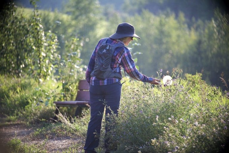
Sitting on over 100 acres of land which backs onto Pat’s Creek, at a dead end road, we are surrounded by quiet wilderness ready for you to come enjoy and explore!
The Peace River Agricultural Society grounds consist of 2 outdoor riding arenas (250′ x 250′ and 125′ x 225′), 3 indoor barns with a total of 40 stalls, 1 outdoor barn with 10 stalls, a Quonset with a stage for bands or dj’s, and a 200 person capacity hall with commercial kitchen, bathrooms and showers, 80 acres of field and trails, camping with 10amp power. It should be noted that horse boarding is only offered during events.
Take advantage of trails, on and off the property, as well as horse boarding services.
With multiple exciting events throughout the year the Peace River Agricultural Society is a staple organization in our region. Come visit us today!
Address: Fairgrounds Rd
Northern Sunrise County
Alberta
T0H 3B0
CanadaTelephone Number: (780) 618-8258Email: pragsociety@gmail.comSitting on over 100 acres of land which backs onto Pat’s Creek, at a dead end road, we are surrounded by quiet wilderness ready for you to come enjoy and explore!
The Peace River Agricultural Society grounds consist of 2 outdoor riding arenas (250′ x 250′ and 125′ x 225′), 3 indoor barns with a total of 40 stalls, 1 outdoor barn with 10 stalls, a Quonset with a stage for bands or dj’s, and a 200 person capacity hall with commercial kitchen, bathrooms and showers, 80 acres of field and trails, camping with 10amp power. It should be noted that horse boarding is only offered during events.
Take advantage of trails, on and off the property, as well as horse boarding services.
With multiple exciting events throughout the year the Peace River Agricultural Society is a staple organization in our region. Come visit us today!
-
SavePlace Title: Peace Valley Snow RidersPlace Description:
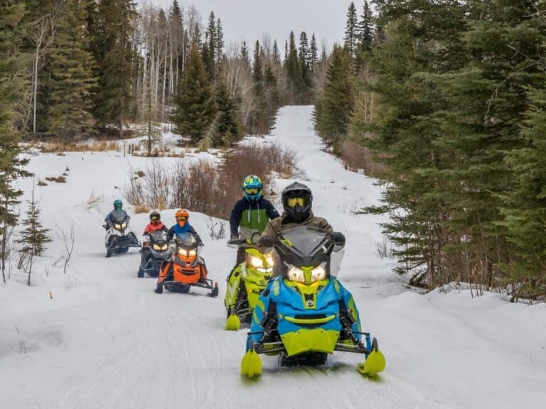
The Peace Valley Snow Riders are a group dedicated to helping families and friends get out of the house and enjoy the Mighty Peace this winter. Their mission is to promote responsible snowmobiling in the Peace Region and develop trails that form a network on both the east and west side of Peace River. Each trail has rest stops with fire pits, picnic tables, outhouses and firewood.
With many sights and scenery to appreciate, riding their trails is a must this winter!
Events:
Peace Valley Snowriders Poker Rally
📅 February 15, 2026 | 📍 Baytex Wesley Creek Trail-
- Sunday February 15, 2026
- Baytex Wesley Creek Trail
- Registration 10 am to 12 pm
Ride the trails and play your hand at this winter favourite! Registration runs 10am–12pm at the staging area, with $10 per hand and a split poker pot (1st 60%, 2nd 25%, 3rd 15%), plus a 50/50 draw and door prizes for kids and adults. Wrap up the day with a social fire and wiener roast at 4pm.
Snowmobiles and tracked OHVs only. ASA day pass or annual membership required.
Memberships & Trail Passes
Memberships and trail passes can be purchased online at albertasnowmobile.ca.
Category: Attractions, Dark Sky Adventures, Town of Grimshaw, Village of Hines Creek, Mighty Peace Essentials, Outdoors, Parks & Lakes, Town of Peace River, M.D. of Peace, Sights & Experiences, Town of Saint Isidore, and Winter ActivitiesAddress: Leddy Lake Staging Area
Dixonville
Alberta
T0H 1E0
CanadaThe Peace Valley Snow Riders are a group dedicated to helping families and friends get out of the house and enjoy the Mighty Peace this winter. Their mission is to promote responsible snowmobiling in the Peace Region and develop trails that form a network on both the east and west side of Peace River. Each trail has rest stops with fire pits, picnic tables, outhouses and firewood.
With many sights and scenery to appreciate, riding their trails is a must this winter!
Events:
Peace Valley Snowriders Poker Rally
📅 February 15, 2026 | 📍 Baytex Wesley Creek Trail-
- Sunday February 15, 2026
- Baytex Wesley Creek Trail
- Registration 10 am to 12 pm
Ride the trails and play your hand at this winter favourite! Registration runs 10am–12pm at the staging area, with $10 per hand and a split poker pot (1st 60%, 2nd 25%, 3rd 15%), plus a 50/50 draw and door prizes for kids and adults. Wrap up the day with a social fire and wiener roast at 4pm.
Snowmobiles and tracked OHVs only. ASA day pass or annual membership required.
Memberships & Trail Passes
Memberships and trail passes can be purchased online at albertasnowmobile.ca.
-
SavePlace Title: 12 Foot Davis StatuePlace Description:
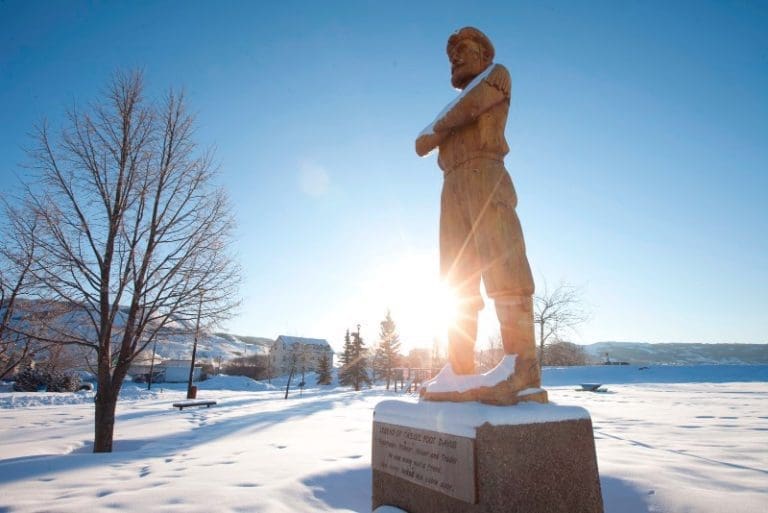
The legendary 12 Foot Davis statue!
Henry Fuller Davis struck it rich in the mid-1800s on a 12 Foot gold claim in northern British Columbia, earning him around $12,000 as well as the “12 Foot Davis” nickname. Spending much of his life as a fur trader on the Peace River, he left his mark on many places in the region and was known for his good business sense and friendliness.
A wooden statue of 12 Foot Davis stands proudly in Riverfront Park, located along the bank of the Peace River, downtown Peace River. The park is complimented by a children’s playground, gazebo, and a beautiful view of the Peace River. A paved walking trail connects the park to the Peace River Museum, Archives and Mackenzie Centre.
Tags: Fall-PhotoAddress: 100 Avenue
Peace River
Alberta
T8S 1J3
CanadaThe legendary 12 Foot Davis statue!
Henry Fuller Davis struck it rich in the mid-1800s on a 12 Foot gold claim in northern British Columbia, earning him around $12,000 as well as the “12 Foot Davis” nickname. Spending much of his life as a fur trader on the Peace River, he left his mark on many places in the region and was known for his good business sense and friendliness.
A wooden statue of 12 Foot Davis stands proudly in Riverfront Park, located along the bank of the Peace River, downtown Peace River. The park is complimented by a children’s playground, gazebo, and a beautiful view of the Peace River. A paved walking trail connects the park to the Peace River Museum, Archives and Mackenzie Centre.
-
SavePlace Title: Twelve Foot Davis GravesitePlace Description:
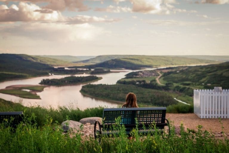
A breathtaking lookout over the Town of Peace River in honor of Henry Fuller Davis, a trader on the Peace River who literally struck gold on a 12 foot claim in the 1860s. The park features include pathways, landscaping, interpretive panels, picnic benches and parking. This is a great viewpoint and photography spot.
Getting There:
Once in the Town of Peace River take Highway 2 South heading up the East Hill. Once at the top of the hill take a left onto Sunrise Road and immediately turn left on Fairgrounds Road. Travel for approximately 1 kilometre, look for signage and turn left on Twelve Foot Davis Road. This road will lead to the gravesite.
Category: Attractions, Northern Sunrise County, Outdoors, Places To See, Sights & Experiences, and Things To DoAddress: Twelve Foot Davis Rd
Northern Sunrise County
Alberta
CanadaA breathtaking lookout over the Town of Peace River in honor of Henry Fuller Davis, a trader on the Peace River who literally struck gold on a 12 foot claim in the 1860s. The park features include pathways, landscaping, interpretive panels, picnic benches and parking. This is a great viewpoint and photography spot.
Getting There:
Once in the Town of Peace River take Highway 2 South heading up the East Hill. Once at the top of the hill take a left onto Sunrise Road and immediately turn left on Fairgrounds Road. Travel for approximately 1 kilometre, look for signage and turn left on Twelve Foot Davis Road. This road will lead to the gravesite.
-
SavePlace Title: World’s Largest Railroad SpikePlace Description:
Where is the World’s Largest Railroad Spike? In Hines Creek!!
When WWII broke out, construction on the railroad in northern Alberta came to a halt – in Hines Creek. The line sat unfinished until well after the war was over, but has long since completed. During the time after the war, the town become known as “the end of steel”, a moniker it has kept ever since.
Address: Hines Creek
Hines Creek
Alberta
T0H 2A0
CanadaWhere is the World’s Largest Railroad Spike? In Hines Creek!!
When WWII broke out, construction on the railroad in northern Alberta came to a halt – in Hines Creek. The line sat unfinished until well after the war was over, but has long since completed. During the time after the war, the town become known as “the end of steel”, a moniker it has kept ever since.