No Records Found
Sorry, no records were found. Please adjust your search criteria and try again.
Google Map Not Loaded
Sorry, unable to load Google Maps API.
-
SavePlace Title: Ole’s LakePlace Description:
Ole’s Lake campground is a hidden gem for campers to enjoy! Relax and kick back in one of the secluded, well treed campsites available. If getting active is your thing – this calm, sparkling lake is a great place for the entire family to swim, paddle board, kayak, canoe or play on the beach! Slow it down with a relaxing walk on the trails and watch for the birds and wildlife that inhabit the area. There is also a great park for kids to enjoy.
The Peace Region’s crisp clear winters can be enjoyed on and around our lakes while ice fishing, cross-country skiing and snowshoeing!
Ole’s Lake is 93km Northwest of Hines Creek on highway 64. Campground open mid May to mid September.
For information call – 780-685-3925
Address: 93km Northwest of Hines Creek on Highway 64
Bear Canyon
Alberta
T0H 0B0
CanadaTelephone Number: 780-685-3925Ole’s Lake campground is a hidden gem for campers to enjoy! Relax and kick back in one of the secluded, well treed campsites available. If getting active is your thing – this calm, sparkling lake is a great place for the entire family to swim, paddle board, kayak, canoe or play on the beach! Slow it down with a relaxing walk on the trails and watch for the birds and wildlife that inhabit the area. There is also a great park for kids to enjoy.
The Peace Region’s crisp clear winters can be enjoyed on and around our lakes while ice fishing, cross-country skiing and snowshoeing!
Ole’s Lake is 93km Northwest of Hines Creek on highway 64. Campground open mid May to mid September.
For information call – 780-685-3925
-
SavePlace Title: Murphy's FlatsPlace Description:
Enjoy a long, sunny northern Alberta summer’s day at Murphy’s Flats. This scenic day use area running along the Smoky River is the perfect spot to enjoy an active day of hiking, fishing, kayaking or canoeing. The river may offer a natural sandy or rocky beach depending on the flow and height of the river water. The nearby Peace River Wildland Provincial Park offers amazing areas for mountain biking and hiking adventurers. A leisurely stroll, rock collecting as well as wildlife and bird watching can be enjoyed by more gentle explorers. Pack a picnic so you can stay all day! There are firepits, tables and free firewood available. This newly developed area is open from the May long weekend to the October long weekend.
To access this area from Highway 744 near Marie Reine, turn west onto TWP RD 822, then turn left on RGE RD 222.5 and turn right onto 821.5 or alternately turn off Highway 744 west onto TWP RD 820, then turn right on RGE RD 222 and turn right onto 821.5.
Day use only.
For more information call – 780-624-0013
Address: Northern Sunrise County
Northern Sunrise County
Northern Sunrise County
T8S 1Y9
CanadaTelephone Number: 780-624-0013Enjoy a long, sunny northern Alberta summer’s day at Murphy’s Flats. This scenic day use area running along the Smoky River is the perfect spot to enjoy an active day of hiking, fishing, kayaking or canoeing. The river may offer a natural sandy or rocky beach depending on the flow and height of the river water. The nearby Peace River Wildland Provincial Park offers amazing areas for mountain biking and hiking adventurers. A leisurely stroll, rock collecting as well as wildlife and bird watching can be enjoyed by more gentle explorers. Pack a picnic so you can stay all day! There are firepits, tables and free firewood available. This newly developed area is open from the May long weekend to the October long weekend.
To access this area from Highway 744 near Marie Reine, turn west onto TWP RD 822, then turn left on RGE RD 222.5 and turn right onto 821.5 or alternately turn off Highway 744 west onto TWP RD 820, then turn right on RGE RD 222 and turn right onto 821.5.
Day use only.
For more information call – 780-624-0013
-
SavePlace Title: McLennan Municipal Kimiwan CampgroundPlace Description:
A warm welcome awaits visitors at the Kimiwan Lake Municipal Campground in the Town of McLennan. This campground is conveniently located within town limits for visitors to access amenities like groceries, laundromat services and fuel. Visitors can self-register before choosing one of the 18 available sites. Choose a serviced or non-serviced site, both have fire pits and picnic tables, and prepare to enjoy a relaxing stay in this beautiful area. There is also an inviting day use area for an impromptu picnic and a fully stocked pond for fishing. This is the perfect spot to set off from and explore the nearby Kimiwan Lake Bird Walk and Interpretive Centre as well as the Railway Museum. There’s something for everyone with The Smoky River Regional Golf Course nearby for those interested in hitting the links! Little campers will also enjoy the playground and wooden train play centre as well as the catch and release fish pond that is within the campground area. Campers will also find a shelter with a cook stove, washrooms, showers, sewage disposal, town water and free firewood are all available to make their stay more comfortable. The campground is open May 1st – September 30th.
For more information contact the McLennan town office at 780-324-3065.
2022 Camping Fees 12 Power Sites (30 amp)
$30/night
$150/week
$550/month6 Non-Service Sites
$20/night
$120/week
$450/monthGroup rate is $200/night, to book all 18 stalls for private functions.
Address: Bousfield Avenue
McLennan
Alberta
T0H 2L0
CanadaTelephone Number: 780-324-3065A warm welcome awaits visitors at the Kimiwan Lake Municipal Campground in the Town of McLennan. This campground is conveniently located within town limits for visitors to access amenities like groceries, laundromat services and fuel. Visitors can self-register before choosing one of the 18 available sites. Choose a serviced or non-serviced site, both have fire pits and picnic tables, and prepare to enjoy a relaxing stay in this beautiful area. There is also an inviting day use area for an impromptu picnic and a fully stocked pond for fishing. This is the perfect spot to set off from and explore the nearby Kimiwan Lake Bird Walk and Interpretive Centre as well as the Railway Museum. There’s something for everyone with The Smoky River Regional Golf Course nearby for those interested in hitting the links! Little campers will also enjoy the playground and wooden train play centre as well as the catch and release fish pond that is within the campground area. Campers will also find a shelter with a cook stove, washrooms, showers, sewage disposal, town water and free firewood are all available to make their stay more comfortable. The campground is open May 1st – September 30th.
For more information contact the McLennan town office at 780-324-3065.
2022 Camping Fees 12 Power Sites (30 amp)
$30/night
$150/week
$550/month6 Non-Service Sites
$20/night
$120/week
$450/monthGroup rate is $200/night, to book all 18 stalls for private functions.
-
SavePlace Title: Haig LakePlace Description:
Known for fantastic fishing with a gorgeous backdrop, Haig Lake is worth the drive. Located in the Woodland Cree First Nation, this 881.8ha lake has pickerel, whitefish and jackfish. If you don’t feel like fishing, you can enjoy the day on your motorized boat, canoe, paddleboard or kayak. Nestled in pristine backcountry, the peace and tranquillity experienced here are second to none. They also have eight unserviced camping sites, firepits, picnic tables, a hiking trail and excellent cell phone service if you need to stay connected.
Get there: Take Highway 743 north to highway 986, turn left onto Township Road 871A. Haig Lake is approximately 1.5 hours northeast of Peace River.
Tags: Must-See FishingAddress: Haig Lake
Woodland Cree First Nation
Alberta
CanadaTelephone Number: (780) 629-3803Known for fantastic fishing with a gorgeous backdrop, Haig Lake is worth the drive. Located in the Woodland Cree First Nation, this 881.8ha lake has pickerel, whitefish and jackfish. If you don’t feel like fishing, you can enjoy the day on your motorized boat, canoe, paddleboard or kayak. Nestled in pristine backcountry, the peace and tranquillity experienced here are second to none. They also have eight unserviced camping sites, firepits, picnic tables, a hiking trail and excellent cell phone service if you need to stay connected.
Get there: Take Highway 743 north to highway 986, turn left onto Township Road 871A. Haig Lake is approximately 1.5 hours northeast of Peace River.
-
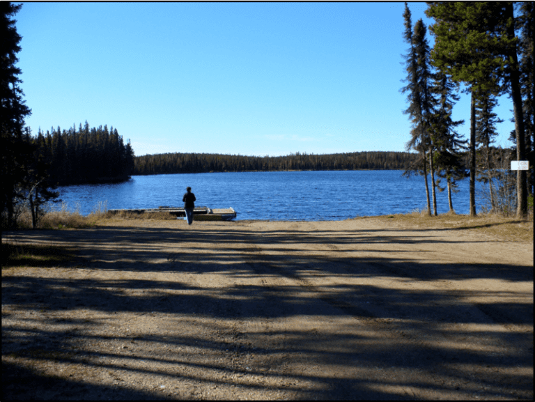
SavePlace Title: Figure Eight LakePlace Description:
Figure Eight Lake Provincial Recreation Area is located 40 kilometers northwest of Peace River on Highway 737 in the County of Northern Lights. Figure Eight Lake takes its name from the shape it had before 1970 when the water level was low, in these earlier days the lake had two basins and resembled a figure eight.
Get There: Figure 8 Lake is 45 km west of Peace River on Highway 737.
GPS Lat/Long:
56.3007800, -117.909248
Category: Accommodations, Campgrounds, Circle Tour, Dark Sky Adventures, County of Northern Lights, and Parks & LakesAddress: Located 8 kilometers north of Grimshaw, then 20 km west on Highway 737.
MD of Peace
Alberta
T0H 1E0
CanadaTelephone Number: (780) 624-6486Figure Eight Lake Provincial Recreation Area is located 40 kilometers northwest of Peace River on Highway 737 in the County of Northern Lights. Figure Eight Lake takes its name from the shape it had before 1970 when the water level was low, in these earlier days the lake had two basins and resembled a figure eight.
Get There: Figure 8 Lake is 45 km west of Peace River on Highway 737.
GPS Lat/Long:
56.3007800, -117.909248
-
SavePlace Title: Wilderness ParkPlace Description:
Searching for a back to nature experience?
Head out to the Wilderness Park located approximately 11km west of Peace River; the path into the area is as beautiful as the park itself! This day use area has picnic tables, fire pits, outhouses and man-made ponds to enjoy! Swimming is not allowed but fishing enthusiasts bring your fishing rods as the ponds are stocked with rainbow trout and grayling! There are docks to fish from and to launch your canoe, kayak or paddle board. Hiking trails abound in the area, part of which include the Trans Canada Trail! Bring your binoculars and enjoy some bird watching, this area is abundant with wildlife. A crackling campfire is the perfect end to a day of fun at Wilderness Park! Please reduce visitor’s impact on the park by taking your garbage home with you. Park closes at 11pm.
Category: Accommodations, Circle Tour, Dark Sky Adventures, Outdoors, Parks & Lakes, M.D. of Peace, Sights & Experiences, Trails, and Winter ActivitiesAddress: Grimshaw
Grimshaw
Alberta
T0H
CanadaSearching for a back to nature experience?
Head out to the Wilderness Park located approximately 11km west of Peace River; the path into the area is as beautiful as the park itself! This day use area has picnic tables, fire pits, outhouses and man-made ponds to enjoy! Swimming is not allowed but fishing enthusiasts bring your fishing rods as the ponds are stocked with rainbow trout and grayling! There are docks to fish from and to launch your canoe, kayak or paddle board. Hiking trails abound in the area, part of which include the Trans Canada Trail! Bring your binoculars and enjoy some bird watching, this area is abundant with wildlife. A crackling campfire is the perfect end to a day of fun at Wilderness Park! Please reduce visitor’s impact on the park by taking your garbage home with you. Park closes at 11pm.
-
SavePlace Title: Cummings Lake Recreation AreaPlace Description:
This camping and recreation area, is a true hidden gem just north of the Town of Fairview. This beautiful recreation area is quiet and cozy, and features a small lake as well as group and individual camping spots tucked into a lush forested area. Keep everyone entertained with a variety of activities available in the area. Canoe, kayak or paddle board on the lake and watch for the many species of birds that also enjoy the water! Walk, jog or run on the 11km of trails that connect the area with the Town of Fairview as well as the Fairview Golf Course. Watch for wildlife that is often spotted near the trail! There are horse shoe pits and a play ground available for visitors as well. During your stay take a stroll over to the Fairview Pioneer Museum that is adjacent to the campground and learn about the early settlers of the area. The area also features ball diamonds and soccer fields. After a busy day of fun, relax around a cozy campfire and enjoy a spectacular Peace Country sunset!
Located on highway 732, approximately 3 minutes north of the Town of Fairview.
Cummings Lake Trail System (PDF – Download)
Cummings Lake Campground (PDF – download)Fairview Bee Pollinator Garden
Immerse yourself in a pollinator’s paradise! The Fairview Agricultural Society has developed a scenic and welcoming pollinator garden, complete with a bench and picnic table, easily accessed from the Cummings Lake Walking Trail. Stop in and enjoy the sounds and smells of summer amidst a variety of beautiful native plants, and check out the pollinator hotel and educational signage as well. This is the perfect spot to take a moment to learn about ways we can support Alberta’s native pollinators such as bees, wasps, and butterflies. You’ll be inspired to try some pollinator friendly gardening practices in your own space!For more information and location details, please visit – https://fairviewagsociety.com/pollinator-garden-project/
Fairview Pollinator Garden Map
Fairview Pollinator Garden Brochure<Winter Cross Country Skiing:
The trailhead can be reached by following a lane north from the intersection of 108 Ave and 108 St. This short lane leads to a parking lot. From the parking lot users pass through a pass through opening in the fence, across the plowed paved walking path to find the cross country ski trail a few metres away.
Category: Accommodations, Campgrounds, Dark Sky Adventures, Fishing, Outdoors, Parks & Lakes, Town of Fairview, and TrailsAddress: Fairview
Fairview
Alberta
T0H 1L0
CanadaTelephone Number: 780-835-5461Email: reception@fairivew.caThis camping and recreation area, is a true hidden gem just north of the Town of Fairview. This beautiful recreation area is quiet and cozy, and features a small lake as well as group and individual camping spots tucked into a lush forested area. Keep everyone entertained with a variety of activities available in the area. Canoe, kayak or paddle board on the lake and watch for the many species of birds that also enjoy the water! Walk, jog or run on the 11km of trails that connect the area with the Town of Fairview as well as the Fairview Golf Course. Watch for wildlife that is often spotted near the trail! There are horse shoe pits and a play ground available for visitors as well. During your stay take a stroll over to the Fairview Pioneer Museum that is adjacent to the campground and learn about the early settlers of the area. The area also features ball diamonds and soccer fields. After a busy day of fun, relax around a cozy campfire and enjoy a spectacular Peace Country sunset!
Located on highway 732, approximately 3 minutes north of the Town of Fairview.
Cummings Lake Trail System (PDF – Download)
Cummings Lake Campground (PDF – download)Fairview Bee Pollinator Garden
Immerse yourself in a pollinator’s paradise! The Fairview Agricultural Society has developed a scenic and welcoming pollinator garden, complete with a bench and picnic table, easily accessed from the Cummings Lake Walking Trail. Stop in and enjoy the sounds and smells of summer amidst a variety of beautiful native plants, and check out the pollinator hotel and educational signage as well. This is the perfect spot to take a moment to learn about ways we can support Alberta’s native pollinators such as bees, wasps, and butterflies. You’ll be inspired to try some pollinator friendly gardening practices in your own space!For more information and location details, please visit – https://fairviewagsociety.com/pollinator-garden-project/
Fairview Pollinator Garden Map
Fairview Pollinator Garden Brochure<Winter Cross Country Skiing:
The trailhead can be reached by following a lane north from the intersection of 108 Ave and 108 St. This short lane leads to a parking lot. From the parking lot users pass through a pass through opening in the fence, across the plowed paved walking path to find the cross country ski trail a few metres away.
-
SavePlace Title: Notikewin Provincial ParkPlace Description:
Take the scenic drive to Notikewin Provincial Park which is 35 km North of Manning on Hwy 35 and 30 km East on Highway 692. Relax and enjoy this quiet well treed campground which offers 19 inviting sites and a day use area. Situated at the confluence of the Peace and Notikewin Rivers, this campground offers amazing views. Enjoy excellent Walleye and Northern Pike fishing right from shore! Hand launch boats and canoes at an open area along the shoreline for some relaxing exploration of the waterway. The whole family can hike the trails and enjoy viewing the birds and wildlife that inhabit this beautiful wild area.
Step back into the past and imagine the history of this area. Notikewin is from the Cree word for battle! It is said that in the 1700’s, The Beaver Tribe and the invading Cree Tribe battled many times in this area. The Hudson’s Bay Company established the Battle River House trading post upstream from the mouth of the Notikewin River. The Battle River House was located east of the mouth of the Notikewin River and was in use for almost 30 years. Time has erased most of the evidence of the post but traces of a cabin built in the 1920’s for use by trappers can still be seen south of the day use area.
Category: Accommodations, On the Peace River, Campgrounds, County of Northern Lights, Outdoors, and Parks & LakesAddress: Located 37 kilometers north of Manning on Highway 35, then 30 km east on Highway 692 (on the Peace River).
Manning
Alberta
T0H
CanadaTake the scenic drive to Notikewin Provincial Park which is 35 km North of Manning on Hwy 35 and 30 km East on Highway 692. Relax and enjoy this quiet well treed campground which offers 19 inviting sites and a day use area. Situated at the confluence of the Peace and Notikewin Rivers, this campground offers amazing views. Enjoy excellent Walleye and Northern Pike fishing right from shore! Hand launch boats and canoes at an open area along the shoreline for some relaxing exploration of the waterway. The whole family can hike the trails and enjoy viewing the birds and wildlife that inhabit this beautiful wild area.
Step back into the past and imagine the history of this area. Notikewin is from the Cree word for battle! It is said that in the 1700’s, The Beaver Tribe and the invading Cree Tribe battled many times in this area. The Hudson’s Bay Company established the Battle River House trading post upstream from the mouth of the Notikewin River. The Battle River House was located east of the mouth of the Notikewin River and was in use for almost 30 years. Time has erased most of the evidence of the post but traces of a cabin built in the 1920’s for use by trappers can still be seen south of the day use area.
-
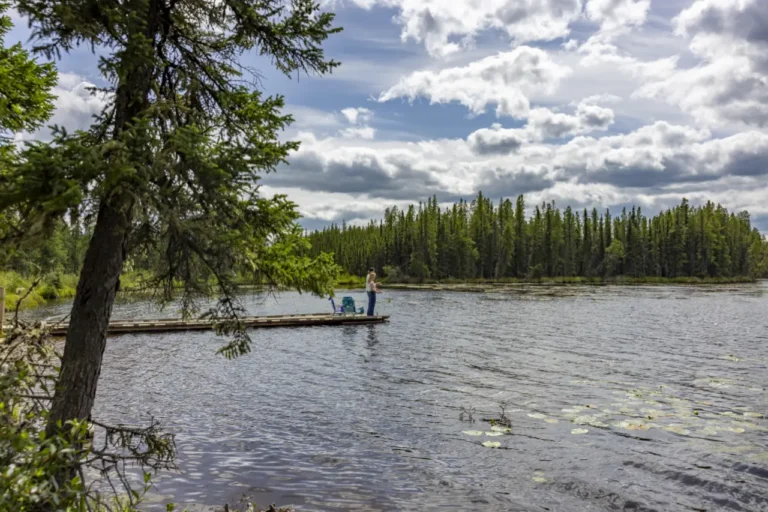
SavePlace Title: Running LakePlace Description:
Cozy, well treed camping sites near the shore of Running Lake are available to visitors planning a day trip or a longer stay. Campers will have outdoor toilets, fire pits, picnic tables and a picnic shelter available. The calm clear lake provides opportunities to swim, paddle board, canoe or kayak! Fishing enthusiasts can cast a line from the pier or their non motorized boat! A fish cleaning station is available as well as a boat launch area. There is something for everyone to enjoy at the play ground and on the hiking/biking trails. Enjoy a crisp clear winter day by going ice fishing on the lake or doing some snowshoeing and cross-country skiing on the ungroomed trails.
Running Lake is a scenic drive 8km East and 22km North of Worsley. The campground is open mid May to mid September.
For information please call – 780-685-3925
Address: Worsley Airport
Worsley
Alberta
T0H 3W0
CanadaTelephone Number: 780-685-3925Cozy, well treed camping sites near the shore of Running Lake are available to visitors planning a day trip or a longer stay. Campers will have outdoor toilets, fire pits, picnic tables and a picnic shelter available. The calm clear lake provides opportunities to swim, paddle board, canoe or kayak! Fishing enthusiasts can cast a line from the pier or their non motorized boat! A fish cleaning station is available as well as a boat launch area. There is something for everyone to enjoy at the play ground and on the hiking/biking trails. Enjoy a crisp clear winter day by going ice fishing on the lake or doing some snowshoeing and cross-country skiing on the ungroomed trails.
Running Lake is a scenic drive 8km East and 22km North of Worsley. The campground is open mid May to mid September.
For information please call – 780-685-3925
-
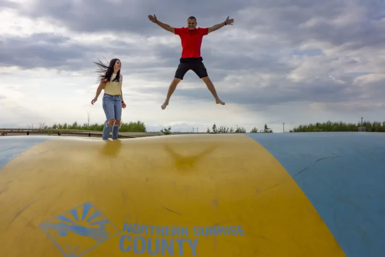
SavePlace Title: Cecil Thompson ParkPlace Description:
Community Park and Campground, the bouncy pillow at Cecil Thompson Park has fast become a landmark in the community of Northern Sunrise County. In addition to the bouncy pillow the park features; challenging outdoor exercise equipment, a wonderful fishing pond, a beautiful gazebo and a walking bridge. A perfect location to spend the day or spend the night at one of the 5 unserviced lots, available first come first serve at no charge.
The bouncy pillow is available from 8am – 10pm, 7 days a week.
Category: Accommodations, Attractions, Campgrounds, Fishing, Northern Sunrise County, Outdoors, Parks & Lakes, and Things To DoTags: Must-See FishingAddress: Pioneer Road
Saint Isidore
Alberta
T0H 3B0
CanadaTelephone Number: (780) 322-3831Community Park and Campground, the bouncy pillow at Cecil Thompson Park has fast become a landmark in the community of Northern Sunrise County. In addition to the bouncy pillow the park features; challenging outdoor exercise equipment, a wonderful fishing pond, a beautiful gazebo and a walking bridge. A perfect location to spend the day or spend the night at one of the 5 unserviced lots, available first come first serve at no charge.
The bouncy pillow is available from 8am – 10pm, 7 days a week.
-
SavePlace Title: Stoney LakePlace Description:
Well treed, private camping sites near the shore of Montagneuse Lake within the Stoney Lake Recreational area are available to visitors looking to get away from it all and enjoy some nature! This is a user-maintained campground with firepits and picnic tables available. The calm clear lake provides opportunities to swim, paddle board, canoe or kayak! Fishing enthusiasts can cast a line from the pier or their non motorized boat! There is a boat launch available. There is something for everyone to enjoy in this beautiful and remote area. Many different species of birds and wild animals can be enjoyed while hiking or mountain biking the area trails. Don’t forget you can also enjoy a crisp clear winter day by going ice fishing on the lake or doing some snowshoeing and cross-country skiing on the ungroomed trails.
Stoney Lake Recreation Area is a scenic drive 50km North of Fairview or 20km North of Hines Creek. The campground is open mid May to mid September.
For information please call – 780-624-6486
Address: Hines Creek
Hines Creek
Alberta
T0H 0B6
CanadaWell treed, private camping sites near the shore of Montagneuse Lake within the Stoney Lake Recreational area are available to visitors looking to get away from it all and enjoy some nature! This is a user-maintained campground with firepits and picnic tables available. The calm clear lake provides opportunities to swim, paddle board, canoe or kayak! Fishing enthusiasts can cast a line from the pier or their non motorized boat! There is a boat launch available. There is something for everyone to enjoy in this beautiful and remote area. Many different species of birds and wild animals can be enjoyed while hiking or mountain biking the area trails. Don’t forget you can also enjoy a crisp clear winter day by going ice fishing on the lake or doing some snowshoeing and cross-country skiing on the ungroomed trails.
Stoney Lake Recreation Area is a scenic drive 50km North of Fairview or 20km North of Hines Creek. The campground is open mid May to mid September.
For information please call – 780-624-6486